Floods Modelling Using High-Resolution Climate Simulations
Purchased from Istock.com. Copyright.
Flooding is a great concern around the world. The social, economic, and environmental impacts of these extreme events and the potential effects of climate change have highlighted the need to improve our understanding of this process. Therefore, hydrological models coupled with climate simulations are used to make flood estimates on past, present, and possible future conditions. Currently, climate simulations are constantly enhanced thanks to computational innovations allowing for higher-resolution simulations that consequently influence floods modelling. Therefore, this study analyzed the effects of higher-resolution climate simulations on floods modelling over 50 river basins in Quebec. Floods simulations showed clear systematic impacts due to the different resolutions. Peak discharges were larger when using finer resolutions. Moreover, these effects were larger in the “most” extreme flood events. Key words: Floods modelling, Climate simulations, Spatial resolution, Hydrological modelling
Floods: A Major Impact on Societies
Around the world, floods are catastrophic events affecting our societies year after year. In Canada, floods were the most common and costly natural hazard in the past years [1, 2]. Particularly, the province of Quebec was impacted by major floods during the last decades. For instance, the Saguenay flood in 1996, the Richelieu in 2011, the 2017 flood that affected 287 municipalities all over Quebec, and the recent 2019 floods have all lead to high socio-economic impacts [3].
Flooding is a complex hydrological event that can be influenced by anthropogenic factors (e.g. dam failure, land use changes) and/or climate factors, such as heavy or long-lasting precipitation events. Therefore, there have been numerous efforts to assess the impacts of climate change on hydrology, showing that processes of the hydrological cycle such as precipitation, snow and ice melting, evaporation rates, and runoff are affected in both mean and extreme conditions [4, 5]. Moreover, there is a high degree of certainty that climate change will continue to affect hydrological processes in the future [6, 7]. Thus, the latent alterations in extreme hydrologic events like floods are considered one of the most important potential impacts of climate change due to the enormous effects on societies [5, 8]. As a result, this issue has brought multidisciplinary groups of researchers together in an effort to improve our understanding of this complex problem, and identify adaptation strategies for the future [9].
A Complex System Needing Computational Power
The impacts of climate change on floods are usually studied using constantly improved climate simulations to produce different flood scenarios. These climate simulations are obtained from climate models consisting in mathematical representations of the climate system [10]. However, the Earth’s climate system is composed of complex processes happening at very different spatial and temporal scales [11, 12]. These different scales vary over a wide range of magnitudes. In time, cycles and patterns occur from milliseconds to hundreds or thousands of years, while spatially, climate processes happen in micrometres to hundreds of kilometres. Thus, climate models require significant computational power due to the high complexity of representing the global climate system, making computational innovations crucial in improving climate simulations.
Advancements in computational power consistently allow increasing the climate models’ spatial and temporal resolutions, consequently influencing hydrological simulations. For this reason, this study assessed flood simulation sensitivity to the increasing spatial resolution of climate simulations over 50 river basins in the province of Quebec.
First, climate model outputs of the Canadian Regional Climate Model version 5 (CRCM5) at three different resolutions (i.e. 0.11°, 0.22° and 0.44° ≈12, 24 and 48 km) were compared (see Fig.1).
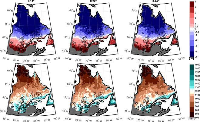
Figure 1 Mean annual temperature (°C, upper panels) and mean annual precipitation (mm, lower panels) at 0.11°, 0.22° and 0.44° (left to right) over the province of Quebec
Figure 1 shows similar patterns at the provincial scale for both temperature (upper panels) and precipitation (lower panels). However, it is possible to notice differences when comparing spatial resolutions at the watershed and local scales as the finer scales are able to give more details than the coarser ones. The bias and relative bias were used to quantify the resolution differences in temperature and precipitation, respectively (results not shown). The results of this inter-comparison showed clear effects of spatial resolution on climate outputs (see full text for more details). The spatial resolution presented up to a 3°C difference in temperature, showing warmer temperatures in the coarser CRCM5 simulations. The inter-comparisons of precipitation simulations showed differences reaching up to 40% in precipitation, relative biases showing dryer summer simulations in the coarser ranges (0.22° and 0.44°).
After analysis of the CRCM5 temperature and precipitation, three different hydrological models were used to evaluate the impacts of CRCM5 spatial resolution on seasonal streamflow and flood simulations. As expected, streamflow simulations and flooding events also presented evidence of the impact of CRCM5 spatial resolutions. The streamflow simulations presented consistent differences between resolutions. Results showed that the larger the spatial resolution difference was between CRCM5 simulations, the larger the difference was between streamflow simulations. Finally, floods were analyzed by using four flood indicators, based on 2-year, 5-year, 10-year and 20-year return periods. Figure 2 shows the results for the 2-year and 20-year return period floods and, in line with the seasonal streamflow analysis, finer resolutions (0.22° against 0.11° in dark blue) presented smaller differences compared to the coarsest (0.44° against 0.22° in light blue) along the four flood indicators. Additionally, these differences showed gradual increases with longer return periods.
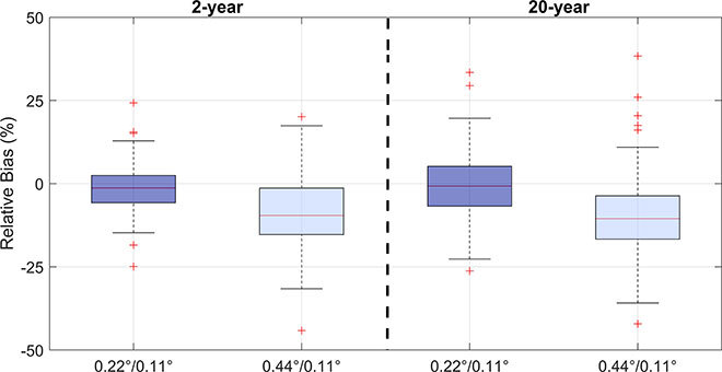
Figure 2 Relative biases (%) between flood indicators (2-year and 20-year) from the streamflow simulated with the different CRCM5 resolutions.
Overall, results show the clear effect of CRCM5 spatial resolutions on streamflow simulations and particularly floods. Thus, as the hydrological community usually uses climate model simulations to produce streamflow scenarios, this work underlines the need to evaluate spatial resolution as a source of uncertainty that needs to be assessed in future works.
Additional Information
For more information, please refer to the following paper:
Castaneda-Gonzalez, M., Poulin, A., Romero-Lopez, R., Arsenault, R., Brissette, F., & Turcotte, R. (2019). Sensitivity of seasonal flood simulations to regional climate model spatial resolution. Climate Dynamics, 53(7), 4337-4354.
Please use the following link provided by the publisher Springer Nature as part of the SharedIt initiative to have the free full-text view-only online version of the paper